Recovered primary filings
- ECF 1-1 — affidavit supporting the complaint, filed December 3, 2025, unsealed December 4. Pages 5–6 list seven data sessions, provider IDs, addresses, azimuths and associated surveillance sightings. Page 7 reports the approximately 19:10 license-plate-reader observation. CourtListener record.
- ECF 17 — government detention memorandum, December 28, 2025. Pages 3–6 describe the surveillance and cell chronology. CourtListener record.
- ECF 50 — government opposition to revocation of detention, January 23, 2026. Pages 3–7 give the chronology; page 4 footnote 1 explains the disputed sector direction; page 7 contains the original tower-and-route graphic. CourtListener record.
These are the government's assertions in filed papers, not independent verification of identity. The recovered papers summarize CAST/provider evidence; they are not the complete CAST report, raw carrier session records, timing-advance dataset, historical sector lists or drive-test measurements. Those underlying records were not recovered in this search. Acquisition URLs and SHA-256 hashes: manifest.
Cell reports shown as P1–P7
January 5, 2021 · EST. P labels count transactions; site labels 1–5 count site/sector records. Sites 2 and 3 share an address. Positions on the map are reported serving-site address references, not handset fixes.
| Report | Time | Site / sector | Provider ID | Reported address | Azimuth |
|---|---|---|---|---|---|
| P1 | 19:39:27 | 1 / A | 59323 | 103 G Street SW | 120° |
| P2 | 19:39:27 | 2 / B | 126187 | 200 Independence Avenue SW | 90° disputed |
| P3 | 19:44:36 | 2 / B | 126187 | 200 Independence Avenue SW | 90° disputed |
| P4 | 19:59:36 | 3 / C | 147990 | 200 Independence Avenue SW | 180° |
| P5 | 20:14:36 | 4 / D | 45111 | 101 Independence Avenue SE | 255° |
| P6 | 20:23:59 | 5 / E | 144340 | 600 Pennsylvania Avenue SE | 295° |
| P7 | 20:24:06 | 5 / E | 144340 | 600 Pennsylvania Avenue SE | 295° |
Source: ECF 1-1, pp. 5–6, paragraphs a–e. The February provider list reportedly said 345° for B; April said 90°. The government cites January/February drive tests in support of the latter. Both directions are selectable on the map.
Brian’s blue northwest comparison points
B1–B7 identify the northwest figure attributed to Brian by Baker/Armitas, using published camera/time anchors: 3192 at 19:57:04; 3188 at 19:59:33; 3187 at 20:01:16; 0600 at 20:01:33; 0601 at 20:03:18; 0602 at 20:04:25; 0940 at 20:05:23. These are camera-area references, with identity/handoffs and clock calibration unresolved. Published presentation · Source analysis.
The court filings identify the southeast hoodie as Cole. They do not independently establish the northwest identification. The map preserves these as distinct attributed comparisons, rather than treating the court narrative as a second verified person track.
Additional chronology in the recovered filing
ECF 50 p. 3 gives approximately 19:34 near First Street/North Carolina Avenue and approximately 19:54 for the DNC placement; pp. 5–6 repeat the already mapped 19:39:32, 19:44:36, 19:59:38, 20:14:15, ~20:16 and ~20:18 surveillance assertions. These do not assign exact times to all eight points in the supplied Gray Hoodie illustration. The first-sighting location also needs reconciliation: ECF 1-1 p. 7 names North Carolina/New Jersey, while ECF 50 p. 3 names First/North Carolina. No new exact coordinate is inferred from that discrepancy.
Supplied annotated map & accompanying argument
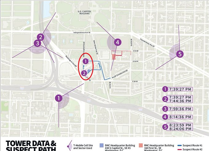
The user supplied this image and argues that the cell evidence does not establish Cole's presence at the crime locations. The accompanying commentary claims the hoodie was outside the drawn sector at the first connection, that observed phone use has no matching Cole session, that timing-advance data is absent, and that vehicle observations/listings do not place his car at the crime locations.
What is supported here: the filings report site connections, not precise handset coordinates. ECF 1-1 p. 5 explicitly says actual sector coverage may be wider or narrower than the diagram. Being outside an idealized fan therefore does not alone prove exclusion. The recovered filings do not provide a timing-advance dataset, a complete phone-use/session comparison, or complete USCP/canvassed-camera and vehicle-of-interest records. Those broader claims remain attributed and unverified here; absence from these filings is not proof the records do not exist. ECF 1-1 p. 7 and ECF 50 p. 3 do report an approximately 19:10 LPR observation at the South Capitol exit from I-395 South, which is not itself a sighting at either device location.
Original filed map for comparison

Supplied image SHA-256: 96b1075d36d8fb076165349b8f89873a3cca9ce46f2c5274a476b20dfb26952e. Original authorship/post URL not independently established from the local filename.